For decades, Mount Everest has held the prestigious title of the world’s tallest mountain, standing majestically at 29,032 feet above sea level. But what if we told you that this iconic peak isn’t actually the tallest mountain on Earth? The answer lies in how we measure height, and when we shift our perspective from sea level to the planet’s core, a surprising contender emerges from the shadows to claim the crown.
The Traditional Height Champion: Mount Everest
Mount Everest, known as Sagarmatha in Nepal and Chomolungma in Tibet, has long captured human imagination as the ultimate climbing challenge. Its towering presence in the Himalayas represents the collision of two massive tectonic plates, the Indian and Eurasian plates, which continue to push this geological giant skyward at a rate of about 4 millimeters per year.
When measured from sea level, Everest’s supremacy is unquestioned. This measurement method, called “height above sea level,” has been the standard for mountain classification since modern surveying began. However, this approach has a fundamental flaw: it assumes that sea level provides a consistent baseline for measurement across the entire planet.
The Problem With Sea Level as a Baseline
Here’s where things get fascinating and counterintuitive. Our planet isn’t a perfect sphere. Earth is an oblate spheroid, meaning it’s slightly flattened at the poles and bulges at the equator. This shape results from the planet’s rotation, which creates centrifugal force that pushes material outward at the equatorial regions.
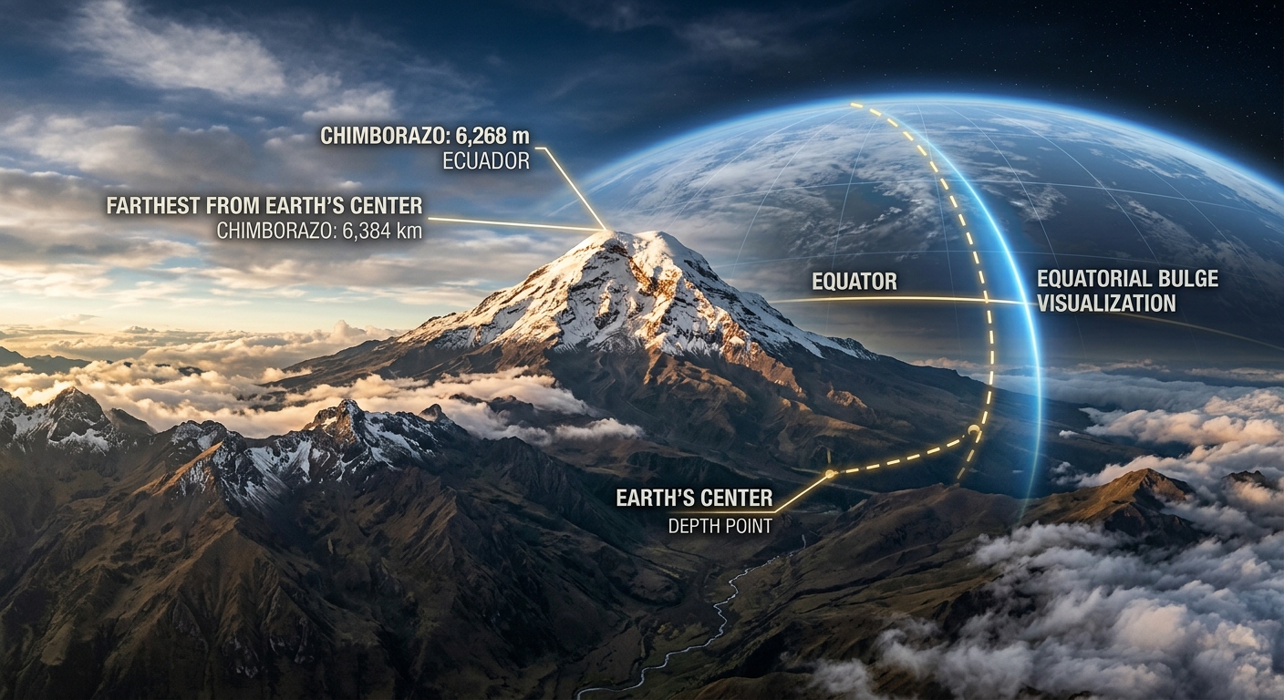
The equatorial bulge means that points along the equator are naturally farther from Earth’s center than points at higher latitudes. This distance difference is substantial, measuring approximately 13 miles (21 kilometers) between the equatorial radius and the polar radius. When we consider this variation, the entire framework for measuring mountain heights shifts dramatically.
The Geoid: Earth’s True Shape
Scientists use a concept called the “geoid” to describe Earth’s actual shape. The geoid represents the shape that Earth’s surface would take if it were covered entirely by oceans and influenced only by gravity. This irregular surface undulates based on variations in gravitational pull caused by differences in rock density, underground structures, and the planet’s rotation.
Enter the Real Champion: Mount Chimborazo
When we measure mountains from Earth’s center rather than sea level, a different peak emerges as the true giant: Mount Chimborazo in Ecuador. This volcanic mountain, standing at 20,564 feet above sea level, might seem modest compared to Everest’s towering height. However, Chimborazo’s strategic location just one degree south of the equator places it in the perfect position to take advantage of Earth’s equatorial bulge.
Due to its equatorial position, Mount Chimborazo’s summit sits approximately 6,800 feet (2,072 meters) farther from Earth’s center than Mount Everest’s peak. This means that if you were to measure the distance from the core of our planet to the mountain’s summit, Chimborazo would win by more than a mile.
The Numbers That Reveal the Truth
Let’s break down the impressive statistics:
- Mount Everest: 29,032 feet above sea level, approximately 3,967 miles from Earth’s center
- Mount Chimborazo: 20,564 feet above sea level, approximately 3,968.3 miles from Earth’s center
- The difference: Chimborazo’s summit extends about 6,800 feet farther into space than Everest’s
Why This Discovery Matters
This revelation about Earth’s tallest mountain highlights the importance of perspective in scientific measurement. It demonstrates how our understanding of geographical features depends entirely on the reference point we choose. The discovery also has practical implications for various fields:
Satellite Technology and GPS
Understanding Earth’s true shape is crucial for accurate satellite positioning and GPS technology. Satellites must account for the planet’s irregular shape to provide precise location data. The same principles that make Chimborazo the “tallest” mountain affect how we calculate distances and positions across the globe.
Climate and Weather Patterns
The equatorial bulge influences atmospheric circulation patterns and weather systems. Mountains like Chimborazo, positioned at high altitudes near the equator, experience unique climate conditions that differ significantly from their sea-level-height equivalents at other latitudes.
Other Contenders in the Height Game
While Chimborazo takes the crown when measured from Earth’s center, other mountains deserve recognition for different types of “tallest” measurements:
Mauna Kea: The True Giant
When measured from base to summit, Hawaii’s Mauna Kea stands as the tallest mountain on Earth. Rising approximately 33,500 feet from the Pacific Ocean floor to its summit, Mauna Kea dwarfs Everest’s height above sea level. However, much of this massive mountain remains hidden beneath the ocean’s surface.
Denali: North America’s King
Alaska’s Denali (formerly Mount McKinley) holds the record for the greatest base-to-summit rise on land, with a vertical gain of about 18,000 feet from its base to its 20,310-foot summit.
The Lesson in Perspective
The story of Mount Chimborazo versus Mount Everest teaches us a valuable lesson about the nature of scientific truth. Facts that seem absolute often depend on the framework we use to measure and understand them. When we change our perspective from sea level to the planet’s center, we discover that our assumptions about the world’s geography need revision.
This geographic revelation reminds us that our planet continues to surprise us with its complexity and that even well-established facts can be challenged when we examine them from new angles. Whether you measure from sea level, Earth’s center, or the ocean floor, each method reveals different aspects of our planet’s incredible geological diversity and the powerful forces that continue to shape our world.
So the next time someone mentions Mount Everest as the world’s tallest mountain, you can share this mind-bending fact: there’s a volcanic peak in Ecuador that actually reaches farther into space, making it the true giant of our planet when measured from the only fixed point that matters, the very center of Earth itself.

oh man this is absolutely brilliant, the way our planet just casually bullies everest like that lol. its giving major planet earth vibes where david attenborough reveals something thatll make you question everything you thought you knew about geography, you know? have you seen any research on how the equitorial bulge affects other geography records or is chimborazo just the special one that gets to steal the crown?
Log in or register to replyThis absolutely blew my mind the first time I learned it, and it still does every time I think about it. There’s something so humbling about realizing that our planet’s shape fundamentally changes what “highest” even means, kind of like how the James Webb discoveries keep reframing what we thought we knew about the universe. Makes you wonder what else we’re measuring wrong just because we’re stuck on this spinning oblate spheroid looking outward.
Log in or register to replyThat equatorial bulge thing really is wild, Sophie, and honestly it reminds me of how spiders have completely reframed what I thought I knew about the natural world too. Like, once you realize a spider’s silk is stronger than steel wire of the same thickness AND can stretch without breaking, suddenly these tiny creatures aren’t just creepy crawlies anymore, they’re these incredible engineers that have been solving problems we’re still figuring out. Great post though, love when science just casually demolishes our assumptions about what we think we know!
Log in or register to reply