Imagine draining an ocean and discovering you could simply walk across it like a vast, muddy field. While this sounds like something from a fantasy novel, the Bering Sea holds this incredible secret beneath its icy waters. This remarkable body of water, separating Alaska from Russia, conceals one of the most fascinating geographical features on our planet.
The Shallow Giant: Understanding the Bering Sea’s Unique Geography
The Bering Sea covers approximately 890,000 square miles, making it roughly the size of the Mediterranean Sea. Yet despite its massive surface area, this northern ocean is surprisingly shallow. The average depth across much of the Bering Sea is only about 160 feet (50 meters), with vast areas measuring less than 100 feet deep.
To put this in perspective, if you could magically remove all the water, you would find yourself standing on what geologists call the Bering Shelf, one of the world’s most extensive continental shelves. This underwater plateau stretches for hundreds of miles, creating a gentle underwater landscape that resembles rolling hills more than the dramatic ocean depths we typically imagine.
The Land Bridge That Changed History
This shallow sea floor isn’t just a geographical curiosity: it’s the remnant of one of the most important land formations in human history. During ice ages, when massive amounts of Earth’s water were locked up in glaciers, sea levels dropped dramatically. The Bering Sea floor emerged as dry land, creating what scientists call Beringia or the Bering Land Bridge.
This temporary continent was no narrow strip of land. At its peak, Beringia stretched nearly 1,000 miles from north to south, creating a massive grassland that connected two continents. For thousands of years, this land bridge served as a highway for both animals and the first humans to reach the Americas.
When the Ocean Floor Was a Superhighway
Between 30,000 and 11,000 years ago, woolly mammoths, giant bison, cave lions, and early humans traversed this now-submerged landscape. Archaeological evidence suggests that the first Americans likely crossed this land bridge, following herds of large game animals that sustained their communities.
The landscape these travelers encountered would have been dramatically different from today’s icy waters. Beringia was a cold but relatively dry grassland, similar to modern-day Alaska’s interior. Rivers meandered across the plain, and despite the harsh climate, it supported a rich ecosystem of plants and animals.
The Science Behind the Shallow Waters
Several geological factors contribute to the Bering Sea’s remarkable shallowness:
- Continental Shelf Extension: The Bering Shelf represents one of the world’s broadest continental shelves, formed by millions of years of sediment deposition and tectonic activity.
- Glacial History: Repeated ice ages carved and shaped the sea floor, creating the relatively flat underwater terrain we see today.
- Sediment Accumulation: Rivers flowing from Alaska and Siberia have deposited enormous amounts of sediment over millennia, gradually filling in what were once deeper basins.
- Tectonic Stability: Unlike more geologically active ocean floors, the Bering Sea sits in a relatively stable region, preventing the formation of deep ocean trenches.
Modern Implications of Ancient Geography
The Bering Sea’s shallow nature profoundly impacts its current ecosystem and economic importance. These shallow waters create ideal conditions for some of the world’s most productive marine ecosystems. Sunlight can penetrate much deeper than in typical ocean environments, supporting massive phytoplankton blooms that form the base of incredibly rich food webs.
A Biological Powerhouse
The combination of shallow depths, nutrient-rich waters, and seasonal ice coverage creates perfect conditions for marine life. The Bering Sea supports:
- Over 450 fish species
- Massive populations of walrus, seals, and whales
- Millions of seabirds
- Some of the world’s largest commercial fisheries
Commercial fishing operations harvest billions of pounds of fish and shellfish annually from these waters, including Alaska pollock, Pacific cod, and various crab species. The shallow waters make these resources more accessible than in deeper ocean environments.
Climate Change and Rising Seas
The Bering Sea’s shallow nature makes it particularly sensitive to climate change. As global temperatures rise and ice coverage decreases, these waters are experiencing some of the most dramatic changes on Earth. The reduced ice cover affects everything from the timing of phytoplankton blooms to the migration patterns of marine mammals.
Interestingly, while current sea levels are rising due to climate change, they would need to drop by only 160 feet on average to expose much of the Bering Sea floor again. While such a dramatic change isn’t expected, it puts into perspective just how recently this area was dry land in geological terms.
Exploring the Underwater Plains
Modern technology allows scientists to map and study the submerged Beringian landscape in incredible detail. Sonar mapping reveals river valleys, lake beds, and other features that existed when this area was above water. Some researchers have even discovered evidence of ancient human settlements on the sea floor.
These underwater archaeological sites provide invaluable insights into how early humans lived and traveled across Beringia. Stone tools and other artifacts recovered from the sea floor help piece together the story of humanity’s epic journey to the Americas.
A Window Into Earth’s Dynamic Past
The next time you look at a map of the Bering Sea, remember that you’re not just viewing a body of water. You’re looking at one of the most historically significant landscapes on Earth, now hidden beneath relatively shallow waves. This underwater realm serves as a powerful reminder of our planet’s dynamic nature and the incredible journeys that shaped human civilization.
The Bering Sea’s secret continues to influence our world today, supporting vast ecosystems and providing insights into our planet’s past. It stands as a testament to the incredible changes Earth has undergone and continues to experience, all hidden beneath waters shallow enough to wade through in many places.
This is such a cool way to think about it – imagine the navigation challenges those early travelers faced, no landmarks, just endless grassland. I’m actually wondering if we could study how modern animals traverse similar featureless terrain (like caribou migrations across tundra) to understand what kind of biological adaptations humans needed back then, or if there’s biomimicry potential in how herds self-organize to find routes across monotonous landscapes.
yo this is wild, thats basically the beringia land bridge but imagining it as this exposed walking route really puts it in perspective. makes me think about how megafauna migrations worked back then, like were there predator prey dynamics similar to what we see on the mara today or was it totally different with those massive ice age animals? would love to know if theres any evidence of how herds moved across that landscape before it got submerged.
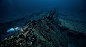
yo i get why ur fascinated by this but honestly the shallow bering sea doesnt really compare to how truly alien the actual deep ocean is lol, like at 160 feet thats basically still sunlit in geologic terms. the real mystery is whats happening at 2000+ meters where creatures produce their own light because your eyes literally cannot exist there without it – that emotional weight of bioluminescence in absolute darkness hits different when you realize those organisms have been evolving in a place we’ve barely explored. but yeah the beringia thing is def cool for understanding early human migration, theres some good evidence of herding patterns from bone deposits