
Deep beneath the Indian Ocean lies a geological marvel so improbable that it challenges our understanding of how Earth’s features form. The Ninety East Ridge stretches for an astounding 5,000 kilometers (3,100 miles) across the ocean floor, maintaining an almost laser-straight line that seems to mock the chaotic nature of tectonic forces.
Named for its position along the 90th meridian east longitude, this underwater mountain chain is not just the longest linear geological feature on our planet, but also the straightest. To put this into perspective, if you could somehow stand this ridge upright, it would stretch from New York to Los Angeles and back again, all while maintaining the precision of a ruler drawn by a cosmic architect.
A Ruler Drawn Across the Ocean Floor
The Ninety East Ridge extends from the Bay of Bengal in the north all the way down to the Kerguelen Plateau in the southern Indian Ocean. What makes this feature truly mind-boggling is its unwavering straightness. While most geological formations on Earth display the irregular, twisted patterns you’d expect from violent tectonic collisions and volcanic chaos, the Ninety East Ridge maintains its course with mathematical precision.
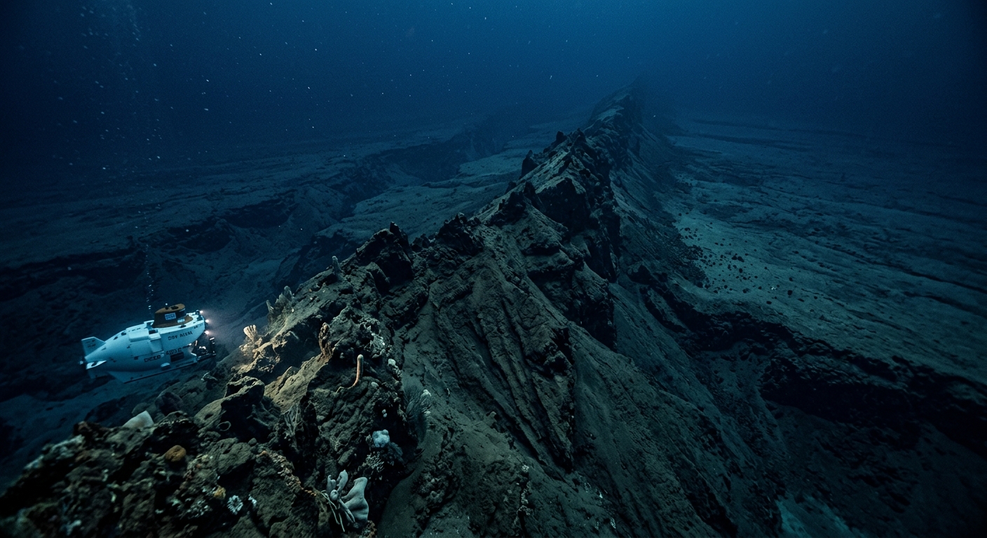
This underwater mountain range rises 1 to 2 kilometers above the surrounding ocean floor, creating a massive wall that divides the Indian Ocean into distinct basins. The ridge’s peaks lie approximately 1,000 to 2,000 meters below the surface, making it one of the most significant but least visible geographical features on our planet.
The Hotspot Trail: How Earth’s Interior Painted a Straight Line
The secret behind the Ninety East Ridge’s remarkable straightness lies in one of geology’s most fascinating phenomena: hotspot volcanism. Unlike the chaotic volcanic activity we see at tectonic plate boundaries, hotspots are stationary plumes of superheated material that rise from deep within Earth’s mantle, possibly from as far down as the core-mantle boundary.
As the Indo-Australian tectonic plate moved northward over the Kerguelen hotspot millions of years ago, this stationary source of volcanic activity left a trail of underwater volcanoes in its wake. Think of it like holding a marker steady while pulling a piece of paper underneath it, the hotspot acted as a fixed point while the moving plate created a continuous line of volcanic peaks.
The Timeline of Creation
Scientists have determined that the Ninety East Ridge formed over approximately 40 million years, from about 82 to 42 million years ago. During this period, the Indo-Australian plate maintained a remarkably consistent direction and speed as it traveled over the Kerguelen hotspot. This geological journey created a chronological record written in stone across the ocean floor:
- Northern sections: The youngest parts of the ridge, formed around 42 million years ago
- Central regions: Created during the middle period of activity, roughly 60-50 million years ago
- Southern portions: The oldest sections, dating back to approximately 82 million years ago
Discovery and Exploration: Unveiling the Invisible Mountain
The Ninety East Ridge remained hidden from human knowledge until the mid-20th century, when advancing sonar technology finally allowed oceanographers to map the deep ocean floor. The first hints of this massive feature emerged during bathymetric surveys in the 1960s, but it wasn’t until comprehensive mapping efforts that scientists realized the true scale and remarkable straightness of this underwater mountain chain.
Deep-sea drilling expeditions in the 1970s and 1980s provided crucial evidence about the ridge’s composition and formation. Core samples revealed basaltic rocks typical of hotspot volcanism, along with sedimentary layers that helped scientists piece together the timeline of the ridge’s creation.
Geological Significance: A Natural Laboratory
The Ninety East Ridge serves as far more than just a geographical curiosity. This formation provides geologists with an unprecedented natural laboratory for understanding plate tectonics, hotspot volcanism, and the history of the Indian Ocean.
Evidence for Plate Motion
The ridge offers some of the clearest evidence for the theory of plate tectonics. By studying the age progression along its length, scientists can calculate the exact speed and direction of the Indo-Australian plate’s movement millions of years ago. This data has proven invaluable for reconstructing the positions of continents and understanding how our planet’s surface has changed over geological time.
Hotspot Dynamics
The formation also provides insights into the mysterious world of mantle plumes and hotspot volcanism. The consistent output and longevity of the Kerguelen hotspot, as evidenced by the ridge’s formation, helps scientists understand how these deep Earth processes operate over millions of years.
Ecological Impact: An Underwater Barrier
Beyond its geological significance, the Ninety East Ridge profoundly influences ocean circulation patterns and marine ecosystems in the Indian Ocean. This massive underwater wall affects the flow of deep ocean currents, creating distinct oceanographic environments on either side of the ridge.
The ridge’s peaks and slopes provide unique habitats for deep-sea organisms, creating isolated ecological niches that have evolved in relative separation from surrounding areas. Marine biologists continue to discover new species and study how this geological barrier has influenced the distribution and evolution of ocean life.
Modern Research and Future Discoveries
Today, the Ninety East Ridge continues to fascinate researchers using cutting-edge technology to unlock its secrets. Advanced seafloor mapping, deep-sea submersibles, and sophisticated drilling techniques provide ever more detailed insights into this remarkable formation.
Recent studies focus on understanding the precise mechanisms of hotspot volcanism, the ridge’s role in ocean circulation, and its influence on regional climate patterns. As our technology advances, scientists expect to uncover even more secrets hidden within this straight-line testament to Earth’s dynamic interior.
The Ninety East Ridge stands as a reminder that our planet still holds countless mysteries, even in an age when we can map distant planets. This perfectly straight line drawn across the ocean floor by geological forces beyond imagination continues to challenge our understanding of how Earth works, proving that the most incredible discoveries sometimes lie hidden beneath the waves.


The Ninety East Ridge is genuinely wild, and your Rift Valley question is spot on – those hotspot trails do show up on land but usually get broken up by erosion and plate tectonics in ways the ocean floor doesn’t. What’s been bugging me lately though is how little we know about what lives *on* these ridge systems and whether they’re acting as stepping stones for deep sea fauna, especially given how fast we’re seeing shifts in invertebrate distributions. Has anyone studied the megafauna corridors along these ridges?
Log in or register to replyok this is absolutely fascinating but now im wondering if theres anything comparable on land that would be visible from like a ground level safari perspective? ive spent way too much time studying the Rift Valley topography for my eventual Serengeti circuit and thats got those dramatic escarpments but nothing remotely this geometric. i guess the key difference is all that tectonic activity is still ongoing in Africa whereas this ridge just got left behind as a perfect fossil record. makes you think about what other massive geological signatures weve just completely missed because theyre underwater
Log in or register to replyThis is so cool, and it really makes me think about how the ocean floor preserves geological history in ways we’re still uncovering. I’m obsessed with extremophile organisms and how they survive in deep sea vents, so features like this always remind me that even the most hostile environments on Earth are shaped by these massive planetary forces. The Arctic seafloor has similar hotspot activity that I don’t think gets nearly enough attention, especially since we’re still mapping how ocean currents and thermal vents interact with changing ice cover up there.
Log in or register to reply