On July 9, 1958, the pristine wilderness of Lituya Bay, Alaska, witnessed something so catastrophic and otherworldly that even seasoned scientists struggled to comprehend its magnitude. A wall of water 524 meters (1,720 feet) tall erupted from the depths of this narrow fjord, creating the largest tsunami in recorded human history. To put this in perspective, this liquid mountain was taller than the Empire State Building and could have easily submerged the Statue of Liberty with room to spare.
The Perfect Storm of Geological Chaos
Lituya Bay sits in the heart of Alaska’s earthquake country, where the Pacific Plate grinds relentlessly against the North American Plate along the Fairweather Fault. This 7-mile-long, T-shaped fjord had already earned a reputation among local Tlingit people as a cursed place, with oral histories warning of the bay’s violent tendencies. Science would soon validate their ancient wisdom in the most spectacular way possible.
The disaster began at 10:16 PM when a magnitude 7.8 earthquake struck the region. But this wasn’t just any earthquake. The tremor triggered a massive landslide on the steep slopes surrounding the bay, sending an estimated 30 million cubic yards of rock, ice, and debris plummeting into the narrow inlet at incredible speed.
The Anatomy of a Monster Wave
When that colossal mass of material crashed into Lituya Bay, it created what scientists call a “splash wave” or “impulse wave.” Unlike typical tsunamis that originate from underwater earthquakes and travel across ocean basins, this was a localized but incredibly violent displacement of water. The physics involved are mind-boggling: imagine dropping a boulder the size of Manhattan into a swimming pool, but scaling up the forces to geological proportions.
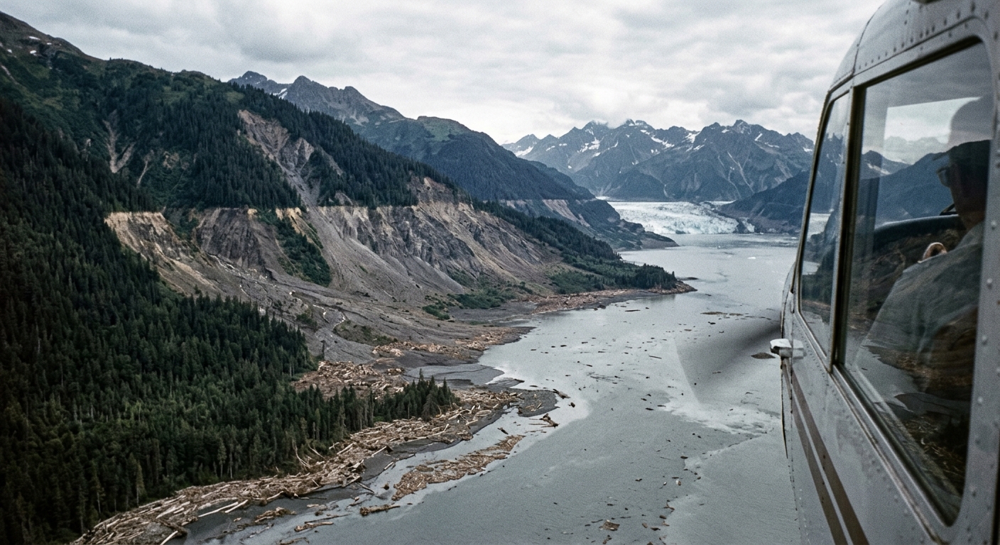
The wave didn’t just rise gradually. Eyewitness accounts describe a wall of water that seemed to appear instantaneously, climbing the opposite slope of the bay with terrifying speed. The water stripped away centuries-old trees, soil, and rock, leaving behind a scar on the landscape that remains visible decades later.
Witnesses to the Impossible
Remarkably, there were human witnesses to this unprecedented event. Three boats were anchored in the bay that evening, and their occupants provided firsthand accounts that helped scientists piece together what happened. Howard Ulrich and his 7-year-old son were aboard the Edrie when the earthquake struck.
Ulrich later described seeing the massive wave approaching: “The wave definitely started in Gilbert Inlet, just before the end of the bay. It was not a wave at first. It was like an explosion, or a glacier slipping into the ocean. The wave came out of the lower part, and looked like the smallest part of the whole thing. The gigantic wave slammed into the island and broke back against the front of Cenotaph Island.”
Miraculously, the Edrie rode out the disaster, though it was carried over trees and deposited back in the bay. The Ulriches survived to tell their incredible tale. Another boat, the Badger, wasn’t as fortunate and was never seen again, along with its two occupants.
The Geological Evidence
The wave left behind unmistakable evidence of its passage. Trees were stripped from the mountainsides up to 524 meters above sea level, creating a distinctive “trimline” that geologists could study for years afterward. This biological damage zone told the story better than any human account: the force of the water was so intense that it scoured away not just vegetation, but several feet of soil and underlying rock.
Not the First Rodeo
As researchers delved deeper into Lituya Bay’s history, they discovered that the 1958 event, while record-breaking, wasn’t entirely unprecedented. The bay had produced massive waves before: in 1854, 1899, and 1936. Each time, landslides triggered by seismic activity created devastating local tsunamis, though none approached the sheer scale of the 1958 giant.
The recurring nature of these events stems from the bay’s unique geography. Its steep-sided walls, glacial activity, and position along an active fault zone create perfect conditions for landslide-generated tsunamis. It’s essentially a loaded geological gun that fires periodically.
Modern Implications and Monitoring
The Lituya Bay tsunami revolutionized how scientists think about these rare but devastating events. It demonstrated that localized tsunamis could reach heights previously thought impossible, with implications for coastal communities worldwide. Places like Norway’s fjords, parts of the Mediterranean, and other glaciated mountainous coastlines now recognize similar risks.
Today, advanced monitoring systems watch for the warning signs of potential landslide tsunamis. Satellite imagery, seismic networks, and computer modeling help scientists identify areas where similar events might occur. The 1958 wave serves as a benchmark for understanding the absolute upper limits of what nature can produce.
Putting the Monster in Perspective
While the 2004 Indian Ocean tsunami and the 2011 Japan tsunami were far more devastating in terms of human casualties, neither approached the raw height of the Lituya Bay wave. Those ocean-crossing tsunamis typically reached heights of 10-40 meters, making the Alaska giant more than ten times taller.
The 1958 event remains a humbling reminder of the incredible forces our planet can unleash. In a remote corner of Alaska, nature demonstrated that under the right conditions, water can become a force capable of reshaping mountainsides and rewriting the rules of what we thought possible.
The next time you look at a tall building or mountain, remember that somewhere in the pristine wilderness of Alaska, the ocean once stood taller, if only for a few terrifying minutes.
That’s absolutely wild, but it makes me think about how we’re still underestimating what nature can do in these fragile coastal ecosystems. I’ve seen how interconnected everything is in rainforest watersheds (the Congo basin drainage alone is mind-blowing), and I wonder if we’re equally blind to the cascading effects of geological events in places like Alaska where indigenous knowledge might tell us stories we’ve forgotten. The fact that this happened just over 60 years ago and we’re still grappling with what it means for coastal communities feels both humbling and concerning given how much we’re already stressing these systems through deforestation and climate change.
Log in or register to replyThis is genuinely one of nature’s most humbling reminders that we’re living on a dynamic planet, and the scale of that 1958 wave still blows my mind. I think what’s wild here, similar to how spider silk can be stronger than steel despite being invisible to most people, is that these massive geologic forces work quietly in the background until they suddenly demand our attention – makes you realize how much respect coastal ecosystems deserve, and honestly how much we still have to learn about what these “fragile” systems are capable of.
Log in or register to replyhonestly this tsunami story is incredible, but what really gets me is thinking about how much of the planet’s most dramatic events happen when most people are asleep – like if this had struck during daylight hours we’d have way more accounts, but it makes you wonder what other massive ecological shifts happen under cover of darkness that we just never witness. the coastal ecosystems around lituya bay probably have nocturnal species that respond to these disruptions in ways we don’t fully understand, and that’s the kind of stuff that fascinates me about night ecology in general.
Log in or register to reply